This item doesn’t have any videos yet
Add New VideoNews | Education
iOS
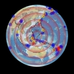
Earthquake Finder provides a visual display of recent earthquake activity on a 3D globe or 2D flat map of the world. Simple, easy to use interface shows the most recent day's quakes upon start. Take more control with pop-up controls to see the previous week's data plus recent volcanic activity. Tap an earthquake to see a list of nearby quakes. For each earthquake in the list the latitude, longitude, magnitude, and depth are displayed. Tap the latitude/longitude to view its location in your browser. Tap a volcano to see a list of nearby volcanoes.
Recent earthquake data is obtained from a USGS data feed and is updated every 5 minutes (requires an internet connection). Data controls allow the user to select a combination of earthquake magnitudes, focus depths and times (one day to one week). Recent volcanic activity or historical earthquake data may also be displayed. Map controls allow you to select which type of plate boundaries are displayed as well as different maps that show physiographic features, continents, or countries. Explore the relationship between earthquakes, volcanoes and tectonic plate boundaries by dynamically selecting these features.
| Published by | Tasa Graphic Arts, Inc. |
| Developed by | Tasa Graphic Arts, Inc. |
| Certificate | 4+ |
| Languages | English |
| Compatibility | iPad, iPhone, iPod |
Images And Data Courtesy Of: Tasa Graphic Arts, Inc..
This content (including text, images, videos and other media) is published and used in accordance
with Fair Use.