This item doesn’t have any media yet
2016 | Sport & Leisure
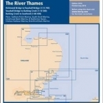
Teddington to Southend in three panels Richmond Bridge to Vauxhall Bridge (1:13 700) Vauxhall Bridge to Barking Creek (1:16 500) Barking Creek to Southend (1:40 400) Plans included: Gallions Point Marina (1:9000) South Dock Marina (1:5000) Limehouse Basin Marina (1:5500) St Katherine Haven (1:5250) Chelsea Harbour Marina (1:2750) Brentford Dock Marina (1:3000) On this 2016 edition depths from the latest surveys have been applied throughout. The chart also now shows the London Gateway Container Port, as well as the revised buoyage in its approaches. Various developments to harbours and jetties are also shown.
| Published by | Imray,Laurie,Norie & Wilson Ltd |
| Edition | Unknown |
| ISBN | 9781846238345 |
| Language | N/A |
Images And Data Courtesy Of: Imray,Laurie,Norie & Wilson Ltd.
This content (including text, images, videos and other media) is published and used in accordance
with Fair Use.