This item doesn’t have any media yet
2014 | Travel
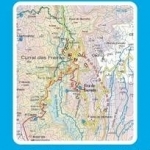
New 2015 8th Edition of our Madeira Tour & Trail Map is available in Super-Durable & Paper versions. Our large 1:40,000 scale, combined with splitting the island into East and West with a generous overlap, produces double sided map whose total size is 840mm by 600mm and folds to 235mm by 120mm. You get the most detailed map of Madeira that is produced including our 'Tour & Trail' level of detail ranging from major roads to secondary roads to minor roads to streets and camino rural narrow country roads, plus dirt roads and walking trails. Altitude background colouring is designed to clearly show the altitude range when travelling across the island by car or on foot. 100 metre and 50 metre contours are clearly shown on the map along with a large number of individual height points and all of the official 'Trig' points. Tour & Trail attention to detail is legendary as is our useful symbol range including miradors, picnic areas, petrol stations, bar/restaurants and parking areas where you can pull off the road safely. You will easily identify springs, caves, sports grounds, cemeterys, churchs, chapels, lighthouses, towers and forts, camping areas, wind turbines, hotels etc.
For adventurers on foot Tour & Trail Maps are researched and designed by hikers for use by hikers. Our comprehensive gps ground surveys produce the best road mapping available but the value of this "on the ground research" becomes even more important when you leave the tarmac. All of our DWG walking routes are accurately gps surveyed giving you confidence in the accuracy of our Tour & Trail Maps. Madeira Tour & Trail Map 8th edition includes all the walking routes from 'Madeira Walks' volumes 1 & 2 by Shirley Whitehead, also published in 2015. It all adds up to the most useful map of Madeira that you can buy anywhere. In use maps have a very tough life so you will appreciate our specialist concertina map fold that allows you to quickly open the map, and more importantly fold it back up to its pocket size after use. Paper maps will always suffer from the repeated unfolding, folding to the section you want to use, and then refolding.
We recommend everybody to obtain our Super-Durable editions printed with 100% oxygenation inks on Polyart by the UK's leading map printer, which produces a map that feels like silk but will stand up to the roughest treatment of outdoor adventuring and yet fold up like new at the end of your adventure. Tour & Trail Super-Durable Maps are more expensive than paper maps, but represent better value.
| Published by | Discovery Walking Guides Ltd |
| Edition | Unknown |
| ISBN | 9781782750031 |
| Language | N/A |
Images And Data Courtesy Of: Discovery Walking Guides Ltd.
This content (including text, images, videos and other media) is published and used in accordance
with Fair Use.