This item doesn’t have any media yet
Weather
iOS
** NOAA Hurricane Tracking and Forecast Data **
Main Features:
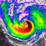
* 8-hour NOAA/NHC Satellite Imagery
* 5-day Hurricane Forecast
* 5-day Tropical Storm Outlook (Pacific)
* 5-day Tropical Storm Outlook (Atlantic)
By far the fastest, most convenient way to access National Hurricane Center data. The app displays 8-hour satellite imagery animations, allowing you to track the storm using the most recent observations. There are 10 filters in total, letting you view the storm from unique perspectives.
Filters Include:
- Visible
- Shortwave IR
- Water Vapor
- RGB
- AVN
- Dvorak
- JSL
- Funktop
- Rainbow
- RBTOP
More satellite filter details below:
-- Visible --
Imagery in the visible spectrum in black and white. Visible only works in daylight, and this image transitions to IR overnight.
-- Shortwave IR --
Shortwave, sometimes considered 'night visible' is taken in the infrared band of light and show relative warmth of objects.
-- Water Vapor --
This image is taken using a wavelength sensitive to the content of water vapor in the atmosphere.
-- AVN --
Shows cloud temperature in aviation colors.
-- Dvorak --
Enhanced infrared, indications of continued development and/or weakening can also be found in the cloud features.
-- JSL --
Developed by Jim Lynch. Used to bring out low level and high level clouds in tropical cyclones.
-- Funktop --
Created by Ted Funk and emphasizes intense areas of precipitation.
-- Rainbow --
Shows cloud temperature with the entire visible specturm.
If you have any questions, feel free to contact me at mwnbdc@gmail.com
| Published by | LW Brands, LLC |
| Developed by | LW Brands, LLC |
| Certificate | 12+ |
| Languages | English, French, Portuguese |
| Compatibility | iPad, iPhone, iPod |
Images And Data Courtesy Of: LW Brands, LLC.
This content (including text, images, videos and other media) is published and used in accordance
with Fair Use.