This item doesn’t have any media yet
2015 | Sport & Leisure
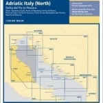
Plans included: Ravenna Coast (1:50 000) Porto di Ravenna (1:20 000) Porto di Rimini (1:10 000) Porto di Fano (1:7500) Porto di Ancona (1:25 000) Porto di San Benedetto del Tronto (1:10 000) Marina di Pescara (1:15 000) For this 2015 edition the chart has been fully updated throughout showing revised depths where required. Various harbour developments are shown at Porto di Ravenna, Porto di Rimini, Porto di Ancona and Marina di Pescara. The plan of Ancona Coast has been removed and replaced with two new harbour plans - Porto di Fano and Porto di San Benedetto del Tronto. The sketch plan of Pescara has been replaced with a fully georeferenced WGS84-compatible plan.
| Published by | Imray,Laurie,Norie & Wilson Ltd |
| Edition | Unknown |
| ISBN | 9781846237010 |
| Language | N/A |
Images And Data Courtesy Of: Imray,Laurie,Norie & Wilson Ltd.
This content (including text, images, videos and other media) is published and used in accordance
with Fair Use.